 Today was a leisurely driving day. It turns out that the only sensible way to get from Grand Teton National Park to Helena, MT (our home away from home for the next little while) is to go through Yellowstone. Perhaps not the best plan for a Saturday, we thought as we approached the Park's South Entrance. Definitely not the best plan, we worried, when the ranger at the gate declined our National Park Pass, telling us in that wholesome, cheery, enthusiastic ranger way that it was a "free weekend."
But our worries were unfounded. We've been to Yellowstone before (and didn't love it), so this time we elected to forgo the usual sights in favor of staying on US 89 and getting through the Park as quickly as possible. Probably because it bypasses the most popular tourist spots, this generally northwesterly route was uncongested even on a free weekend. It twists and turns, mostly at a nice 45mph clip, past some magnificent scenery and wildlife, including the preternaturally serene buffalo in the picture above. (Among the things that did not appear to be troubling this "so ugly he's actually sort of beautiful" creature was his extreme need for lotion and hair conditioner.)
Don't miss the fumaroles in the picture just below. (Click on the picture to see a larger version.) These steam spouts billow out of the ground more or less constantly all over Yellowstone. Like their flashier cousins the geysers, fumaroles are an unexpected and bewitching thrill to the eye; to the mind, they somewhat sinisterly confirm that boiling away not very far underground is the same magmatic heat that powered the violent volcanic eruptions that created, shaped and reshaped Yellowstone's topography.


 Most of Yellowstone is a high volcanic plateau. But the northern portion of the Park and the chunk of south-central Montana you find yourself in immediately after you leave the Park through the North Entrance are more geologically complex.
Landslides, more erodible shales and sandstones, and glacial till deposits of a whole host of rock types make for a very different landscape in this area of the northern range. The soils here have a high clay content. Water binds tightly to clay, which results in very little water being available to sustain plants. In case that alone wasn't enough to discourage plant growth, these soils are also poorly aerated, they resist root growth, and they have high levels of sodium and salts. For all these reasons, the landscape stops looking lushly green and looks instead like this: Sparkling streams, creeks and the impressive Yellowstone River, complete with rafters, kayakers, waders and swimmers, contrast implausibly but gorgeously with this rugged landscape.
We stop for gas in tiny Gardiner, MT, and enjoy both the cowboy boots on the residents, male and female, and the wonderfully named Hellroaring Street we pass on the way out of town. By the time we get to Livingston, it's midafternoon and we're hungry. Relying once again on Jane and Michael Stern's Roadfood book, we head for the Sport Restaurant on Main Street. But for all the trucks and SUVs, the street looks to be straight out of a Western.
After hamburgers topped with a veritable salad of incredibly fresh and delicious lettuce, tomatoes and mushrooms (where on earth could they be from, we wonder), a pile of crisp garlicky fries, and an enjoyable chat with our waiter (David, originally from St. Louis), we hop back in the car, realize that it would really be far more appropriate to unhitch horses and hop on them instead, and head for Helena.
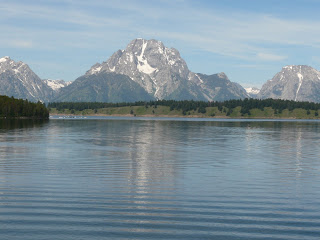
 The Grand Tetons are the youngest of the Rocky Mountains and they are considered the most photogenic. Happily, this is not further evidence of our youth-obsessed culture. It is instead because there are no foothills to obstruct the view of the craggy, snow-dotted peaks as they soar 13,000 feet above sea level and 7000 feet above the Jackson Hole valley. And while the ravishing Tetons are mere babes at 10-13 million years old (as compared to the Rockies at 50 million years old), the rocks of which these youthful beauties are made are among the oldest on earth.
The tale of why there are no foothills leading up to the Grand Tetons and how 2.5-billion-year-old Precambrian rocks ended up rising above the Wyoming plain a mere 13 million years ago is a great illustration of the impacts of three of geology's money players: tectonic plates, glaciers, and erosion. Even if you aren't agog about geology the way I am, stick with me on this. It's a great story.
The earth is comprised of layers around a solid center core. The inner core is estimated to be about 12,000 degrees Fahrenheit. The rock gets progressively cooler and more solid toward the outside. The stuff between the core and the earth's crust is called the mantle, and it comprises the bulk of the planet. The mantle is rock, but it is neither solid nor liquid. It constantly moves and flows, but super-slowly, like gooey taffy or warm plastic. The thin layer of hard rock that consists of the crust and the upper mantle is called the lithosphere. We're still talking pretty hot rock where the mantle meets the lithosphere: over 700 degrees F.
Thanks to the spinning of the planet, the flowing of the mantle under the lithosphere, and differential temperatures all over the earth, the lithosphere is and has always been under a lot of pressure. It responded by breaking up into big puzzle pieces called tectonic plates. Driven by the heat of the circulating, semi-molten mantle underneath, these plates move around, nudging, grating, grinding and occasionally crashing against one another. Sometimes they even ride up on or slide underneath each other. For example, the Pacific Plate has been crowding the North American Plate for eons; these plates meet along the coast of California at the San Andreas fault. You know what happens there.
Between 120 million and 55 million years ago, a plate called the Farallon collided with the North American Plate. The Farallon got pushed under our plate, down into the mantle, and it stuck. This is what allowed the Rockies to be formed so far inland. When the sub-plate fell down into the mantle, a lot of liquid hot magma (as Dr. Evil would say) welled up and caused severe volcanic activity. This created more mountains and it also left a lot of residual heat in the lithosphere.
The heat caused the North American Plate to stretch, spread back out and crack. Since the land was being stretched from east to west, the cracks formed north to south. Cracks are faults and they angle deep into the earth's crust. The Teton fault was thus formed, about 13 million years ago. As the land continued to stretch, the fault pulled apart. One side (Jackson Hole) slid down along the fault, and the other side (the glorious mountain range) rose up. The side that dropped down displaced some of the underlying mantle, which further pushed up the rising side.
The differential is huge - the mountains rise about one foot for every four feet the valley drops. The current differential is about 27,000 feet from mountain top to valley floor. (Stay tuned for why the numbers don't quite seem to work.) And these forces are all still at work: whenever the two chunks of crust move along the fault, there is an earthquake. The Tetons are the product of 13 million years of earthquakes, the last huge one about 4800 years ago.
There are no foothills leading up to the Grand Teton range because the valley sank. The Precambrian rocks of which the young mountains are made were meandering along, minding their own business, in the mantle under the lithosphere until they got displaced by that sinking valley. These ancient rocks are gneiss and granite, metamorphic and igneous rocks (respectively) that are very hard once they cool. They erode at a much slower rate than the sedimentary rocks like shale, limestone, sandstone and siltstone that used to comprise the whole region and still comprise the bulk of Jackson Hole. The softer sedimentary rocks that originally rose up from the earth along the fault line, pushed up by the sinking valley and the harder metamorphic rocks, have eroded completely away but for the ever-shrinking top hat of sandstone Mt. Moran wears to this day.
Where did they go? This post has gotten too long, so I'll give short shrift to my favorite geologic phenomenon of all: glaciers. During the big Ice Age, which began 2 million years ago, thick ice covered the entire region (along with most of the rest of the northern parts of the world). Smaller ice ages followed, the most recent between 50,000-14,000 years ago. The Grand Tetons were buried several times under thousands of feet of ice for tens of thousands of years. Whenever the earth warmed up, the glaciers receded; their movement created the topography we see today.
Glaciers are the big kahuna of sculpting erosion. They bulldoze, carve, scour, polish and striate everything in their path. They also carry along - and then, when they melt, dump - unimaginable tons of eroded material. This is why the Jackson Hole we see is only 7000 or so feet (and not the full differential) lower than the tips of the Tetons: glacial debris filled up the other 20,000 feet.
I'm dying to go into more detail about glaciation, but I fear I might have exhausted even the patience and interest of those who've stuck with me this far. So I'll stop here and leave you with pictures.



 The following picture isn't very good, but I offer it to show you the enormous scale of the place. I took the shot with 18x magnification and still the herd of enormous elk in the middle looks like nothing more than a thin, slightly bumpy brown line. The elk were in a standoff with a bear hoping to separate a tasty baby from its mother.
 Soon after we leave Montpelier, we're in Wyoming. The road quickly climbs 1300 feet and now there are brown mountains behind the green hills, some of them sporting patches of snow gleaming improbably in the summer sun.
Just as quickly, the elevation decreases back to 6200 feet and the rolling hills open out into vast pastures. The mountains ringing the pastures in every direction are still thickly carpeted in green, but the slopes of the eastern range are wearing their evergreens in north-facing Mohawks. They look like so many teenagers rebelling against their fully forested elders to the north, south and west.
Horses chew lazily on the grass in the pastures. Cows lounge in clumps under the warm sun. As everywhere, the cattle have arranged themselves as if they're attending a conference: most in the main meeting, some in breakout groups, a few engaged, apparently, in some form of independent study. Little towns (Smoot, Afton, Etna) appear and disappear without fanfare and not very often. Businesses have names like "Clip & Curl Corral" and "Bull Moose Saloon;" buildings are few and either weathered or falling down altogether. Notwithstanding these indicia of human activity, we see more bales of hay and grass than people, and the breadth, grandeur and verdancy of the vistas bespeak nothing more than undisturbed tranquility.
At Alpine, we join the Snake River (in the picture above). From Alpine to Jackson, the road follows the river as it curves, bends, widens, narrows and generally makes plain how this valley got carved. It is the job of rivers to carve the land, always with the goal of returning to sea level. The Snake still has quite a job ahead of it; its river bed is around 5500 feet above sea level.


 After the town of Alpine, the topography to the west becomes less rolling and more, well, alpine. Nothing craggy or barren yet - we're still far below the timberline - but the angles are steeper than the placid angle of repose and the foliage marching up the slopes mostly hugs the ground. The tall evergreens are now in smaller squadrons, and they appear to be clinging to the mountainsides.
Jackson looks like all yuppie ski resorts. The main streets are pretty much interchangeable with those of Estes Park or Park City, Vail or Beaver Creek. Cute shops, wood-timbered Old West facades, congested streets, restaurants with big city pretensions, the obligatory microbrewery, and more people crammed into a few square yards than we've seen in hundreds of miles.
We get through it as quickly as possible, which isn't very quickly, and then the Grand Tetons, which have been hovering on the horizon to the northwest, are suddenly before us. On one side, we still have the rolling green-clad mountains that have accompanied us since northern Utah:
 On the other side, we have this:

And here's the view from the balcony of the cottage that will be our home for the next couple days:
 I think the Grand Tetons are going to make it possible for me to forgive Wyoming for Yellowstone.
 Today featured a leisurely drive from southern Utah to Montpelier, Idaho, and a world-class BLT.
I feel silly waxing rhapsodic about a sandwich within 24 hours after extolling the geologic splendor of Bryce Canyon, but there you have it.
The Roadfood people note in their rave review of Hire's Big H in Salt Lake City that the BLT is "an unassuming masterpiece." "Deceptively simple" would be a better descriptor than "unassuming," but the sandwich is indeed a masterpiece.
To clarify - and for the benefit of any chefs who decide to embark on the assembly of a truly great bacon, lettuce and tomato sandwich - here are the essential elements:
--First and foremost, the bacon must be cooked to order and only slightly cooled. None of that bendy, glutinous, after-the-fact garbage; the BLT can only reach perfection when the bacon is freshly cooked, crisp and still warm.
--The tomatoes must be ripe, red, cold and sliced about the width of a pinkie finger.
--The lettuce may be leafed (my preference) or torn into bite-sized pieces, but it must be fresh, crisp and cold.
--The mayonnaise must be the real deal - smooth, creamy and white. Nothing ecru or goopy or filled with chemicals. There must be enough for a teardrop or two to squeeze out while you eat, but not so much that the sandwich sobs.
--Finally, and nearly as important as the bacon, is the bread. Nothing multigrain or sourdough or crusty or fancy in any way. The bread must be white bread, but not, I hasten to add, some soft doughy tasteless abomination. It should be white bread like someone's grandmother from the old country makes - substantial and full of natural flavor - and it should be toasted to a lovely nut brown on both sides. Oh, and there should be only 2 slices of it, both slightly thicker than the tomato slices. This is not some starchy monstrosity we're building; it's an exquisite assembly that someone will still be marveling over hours, possibly days, later.
I think I can tear myself away from blissful contemplation of the BLT long enough to describe the beauties of the drive north. Salt Lake City is always a bit of a production to get out of, what with the traffic and the road construction, but we left before serious rush hour began, so it didn't take us too long to find ourselves in the gorgeous green serenity of northern Utah and southeastern Idaho.
This topography is one of rolling hills, except here the hills rise 2500 feet or more from the roadway, which is itself around 6000 feet above sea level. The air is fresh, pure and semi-arid (no humidity and no frizzing of curly hair). The temperature is in the 70s. The mountains are the gentle, angle-of-repose slopes carved by receding glaciers; with their rounded fissures and cracks, they always look to me like the gigantic paws of colossal animals at rest.
 The whole landscape, in fact, looks like the purview of titans. The scale is vast. No crowding escarpments here. The mountains hang back, like quietly self-confident hosts who know they need not assert themselves to be noticed.
These mountains are densely blanketed in green, from scrub to shrubs to small rounded trees to sentinel-straight ranks of evergreens. It's amazing how many shades of green there are. A few white or yellow wildflowers and some purple shrubs also stud the carpeted slopes, but the overall effect is of a thousand shades of green, from sage to lime to loden and everything in between.
Just before Utah gives over to Idaho, the road opens onto the breathtaking vista of Bear Lake. Its vast acres of cobalt blue water fringed by dark-green-cloaked mountains are impossible to capture photographically (at least by me), but it leaves a mental imprint that cannot be forgotten.
About 30 miles later, we're in Montpelier. There's nothing much there, but after last year's Death March to Bataan drive from Salt Lake City to Yellowstone, we decided to take it easy on this trip. Our destination is the Grand Tetons (missed last year due to said Death March), but tomorrow is soon enough to get there.
I'm a snob where big city hotels are concerned, but on the road I require nothing more in a place to stay than cleanliness, blackout shades, air conditioning, and the delivery by both the bed and the shower of firm pressure. The Clover Creek Inn offers all this, plus the added luxuries of friendly staff, high-speed internet access, a profusion of pillows, and towels a step above typical motel fare. We reconnect briefly with the outside world, then sleep like babies.
One last thing: It seems important to mention that we ate no potatoes in Idaho, a mistake we intend to rectify the next time through.


 One of the reasons I love Utah's National Parks is that they are literally groundswells of geology in action. I have no interest in flora and very little interest in fauna, but I have a passion for geology. I love its all-but-infinite time horizons, its grandiosely broad perspective, its eloquence and its ubiquity.
The geologic story of Bryce Canyon - and of Utah's other National Parks - is primarily a story of water. Rock formations result from erosion, and erosion, even in the desert, is water's handiwork. The day-to-day freeze-thaw cycle of dew, rain, ice and snow sculpts rock by working its expansion-contraction magic over geologic time.
About 60 million years ago, the basin that covered most of southern Utah began to fill with fresh water. For millions of years, rivers and streams from surrounding mountains filled the lake in the basin with silts, clays and sands. Calcium carbonate glued these sediments together and formed the limestone from which Bryce Canyon was carved.
About 16 million years ago, southern Utah began to rise as large faults in the earth's crust pushed up a series of plateaus. The Paunsaugunt Plateau rose from sea level to approximately 8000 feet. The Aquarius Plateau, just to the east, rose 2000 feet higher still. Water erosion began to wear away the limestone even as the plateaus were still rising. Eventually, the softer stone washed away, leaving the spires, arches, walls and, finally, the hoodoos of Bryce Canyon.
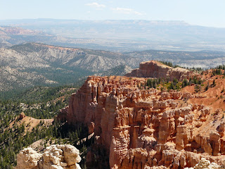
Hoodoos are the pinnacles left behind when ridges, walls and arches wear away and collapse. They go last because they're protected by a layer of harder caprock called dolomite. This erodes too, but at a much slower rate. The differential erosion rates are what cause the crazy shapes. Dolomite can't protect the hoodoos forever, though; they, too, eventually collapse.
One of the coolest things about rock formations like Bruce Canyon is their ephemerality. They seem, and indeed are, permanent when viewed in human terms. But in geologic terms, they are provisional, fleeting, as mortal as we are. Geology has all the time in the world and, given all that time, the same forces that created Bryce Canyon will reduce it to rubble and then replace it with something equally spectacular - again and again and again.
With that said, I'll let profound beauty speak for itself:


 The desert in summer has a beauty, but it is a subtle beauty. Part of its appeal is its essential featurelessness. But for the occasional sprinklings of Joshua trees and other close-to-the-ground dun-colored scrub, the desert is nothing but sand, the many-colored but utterly barren mountain ridges that ring the horizon in every direction, sky of a singularly deep blue, and the hot, clear, brilliant sun. The vistas are huge and panoramic; they don't merely dwarf their constituent parts, they swallow them up. Las Vegas, which admittedly has fantastical elements that would make it unlikely in any setting, seems altogether chimerical within two minutes after it disappears from the rearview mirror.
Between Las Vegas and the northeast Nevada-Arizona border (pat yourself on the back if you knew that a corner of Arizona pokes up between Nevada and Utah), there is almost nothing but limitless desert. But for the road, it's probably looked the same for hundreds of thousands, maybe millions, of years. Well, the road and Mesquite, Nevada, a tacky, hopeful Las Vegas wanna-be. In the summer as it shimmers in the heat, Mesquite seems particularly well named - it looks to be possible to grill a steak on virtually every rooftop, roadway and other sun-scorched surface.
The little spit of Arizona changes everything. Suddenly, the road winds and climbs and the mountains close in. The sun is just as intense, the mountains just as orange and craggy, but the perspective is now primarily vertical rather than horizontal. It is a fitting introduction to Utah, one of the most extravagantly beautiful places on earth.
The diversity of Utah's topography is astonishing; it offers everything from arid desert to dense alpine forests to verdant pastures thousands of feet in the air to fantasy lands of iron-rich sandstone and pearly limestone. Its five national parks - more, I believe, than in any other state - span a tiny band right at the top of the quality spectrum, from the eye-popping splendor of Zion and Arches to the out-of-this-world glory of Capitol Reef, Bryce Canyon and Canyonlands.
Interstate 15, which starts in Los Angeles and goes north, by way of Las Vegas and Salt Lake City, all the way to the Canadian border, was well placed. It occupies the only ugly and boring cylinder of space in Utah. We leave it behind at the first opportunity and wend our way to Bryce Canyon via one of the many scenic byways available to people not in a hurry.
Within the next hundred miles, we gain nearly 8000 feet of elevation and lose just over 40 degrees of temperature. Not too far after the summit at 9910 feet above sea level, Lake Navajo, in the picture above, perches placidly in the rich, dry 71-degree air.
Within 50 miles of Lake Navajo, we encounter the hoodoo-topped red rocks in the pictures below. This topographical diversity is all part of the Dixie National Forest, so named not out of geographical confusion, but because Mormons in the late 1800s sent some of their number to this part of southern Utah to grow cotton.

 Our home for the night is Bryce Canyon Lodge, a historical landmark inside the park that was built by the Union Pacific Railroad early in the 20th century. We wander, somewhat breathlessly inasmuch as we are now at a lung-draining 8500 feet, surrounded by 6-million year old rock formations. The pink cliffs of the Wasatch formation date back to the Cenozoic Era, the time when mammals first appeared on earth.
 More on all that tomorrow. For tonight, content after a dinner of salad and grilled red trout, we walk to the lip of the canyon and watch the sun set behind the alternating soft siltstone and hard limestone layers that millions of years of rain, ice and snow have eroded into fantastical pinnacles, walls, and arches. It is strange to think that sunsets were already old-hat billions of years before these ancient rocks existed.
I am at the coffee shop, having been driven out of my normally quiet home by the clatter and bustle of the cleaning people. In four high-backed upholstered chairs that don't match and have, in any event, seen much better days, sit four teenagers. They have the chairs pulled close around a tiny table - one of those short side tables that serve as central tables in coffee shops.
The little table above which the teenagers' chairs loom is crammed with food and drink, and the teenagers are gobbling. This is surprising. I doubt the three boys and one girl combined weigh 400 pounds. They are, all of them, freakishly skinny, drug addict skinny.
Their clothes and haircuts seem to have been chosen for maximum ugliness. Underwear is visible on all - the boys are sporting colorful tight briefs (the kind little children wear) with either jeans or slimy nylon basketball shorts slung on their palm-width hips, defying gravity; a ramshackle bra, which she does not need, pokes out of the girl's skimpy sundress, itself a plaid the colors of jaundice and fresh bruises. Two of the teenagers are dirty blond, two are dirty brunette; all of their hair is pasted greasily to their skulls and none of it appears to have been cut with any sort of plan or symmetry in mind. One of the blond boys wears a red woolen stocking cap. (This is Las Vegas and it is currently 104 degrees Fahrenheit).
The teenagers' skin keeps the drug addict imagery alive: they have no glow, no tan, no ruddiness, not even the slick shine of acne. They are gray. But for their oddly loud clothing, they could be characters in a black and white movie shot by a bad cinematographer.
How do I see all this? They cannot sit still as they gobble. First one, then another, then the first, then yet another pops up, wanders around the shop, texts, makes a quick call, sits back down. Perhaps all this fidgeting is why their food creates no bulk. Standing, the boys look like long-waisted optical illusions. Their legs are skin-wrapped sticks, seemingly nowhere near sturdy enough to support even emaciated bodies. One of the boys slings his arm around the girl. She smiles, but does not look up at him. Both the line of her jaw and the knobs where her arms meet her shoulders look sharp enough to cut glass.
It is impossible to think of any of them writing a term paper, running for public office, raising children, curing cancer, working in an office building (or, for that matter, in the Peace Corps) or in any other way assuming the mantle of adulthood.
There is no denying it: I am old. What a relief. I am giddy with the realization that my own transition from awkward awful adolescence to adulthood is so far in the past as to be all but beyond recollection.
 Today was a leisurely driving day. It turns out that the only sensible way to get from Grand Teton National Park to Helena, MT (our home away from home for the next little while) is to go through Yellowstone. Perhaps not the best plan for a Saturday, we thought as we approached the Park's South Entrance. Definitely not the best plan, we worried, when the ranger at the gate declined our National Park Pass, telling us in that wholesome, cheery, enthusiastic ranger way that it was a "free weekend."


 Sparkling streams, creeks and the impressive Yellowstone River, complete with rafters, kayakers, waders and swimmers, contrast implausibly but gorgeously with this rugged landscape.


