 I'm not really a fan of those historical tours you can take in almost every city and town. For one thing, they're typically conducted in modes of transportation either so cute it makes your teeth ache (e.g., locomotives like the kiddie trains at amusement parks, double-decker buses, trolley cars, and so forth, all of them inevitably red) or so uncomfortable you soon believe it would be altogether better simply to throw yourself through the window (e.g., noisy diesel buses with cramped, high-backed seats molded to allow only one totally disagreeable sitting position).
For another thing, these tours are always conducted/driven by an enthusiastic, big-personality jokester, the kind of person who asks where everyone is from and instructs the crowd to give Bill the ticket guy a round of applause because he's the one who washed the windows so everyone would have a nice clear view - this on an open-air vehicle that has no windows. Ha-ha. Being an extrovert and a public speaker myself, I feel bad if I leave these people hanging, so I end up playing along and feeling instead both imposed upon and like a chump. It's exhausting, really.
But my husband loves the tours and, with rare exceptions, he's been right about their value, despite the drawbacks. They're a great way to get the lay of the land and a sense of the local scenery and history. The tour in Helena, MT, was not an exception. It took place in a tricked-out locomotive that pulled three open-air cars (the whole thing cherry-red, of course), and it was conducted by an exceptionally chipper woman named Liz who looked about 25, but told us she was the mother of three daughters, two of them teenagers, and the wife of a man who often "feels he's swimming in an estrogen ocean." She also mentioned her father, her brothers and that she's planning a run next year for the Montana state senate.
Liz managed to tell us a great deal about Helena, too, as she trundled her super-cute tour vehicle around town. I owe her - and the Helena Chamber of Commerce website, which disagrees with her on a few matters - a debt of gratitude for the tidbits I've woven into the tale below.
The last of the three huge gold strikes in Montana's history was discovered by four prospectors known for unclear reasons as the Four Georgians. Apparently, only one of them was from Georgia, but all of them had decided to go home empty-handed if they didn't strike gold in the gulch along the Last Chance Creek. The gold they found there in 1864 began one of the largest gold rushes in the West.
 The town site of Helena was first surveyed in 1865, but most of the streets - then and now - meandered as had the miners, following the curves of Last Chance Creek and circumventing miners' claims. Even then, naming things Last Chance one thing or another must have been irresistible. It certainly is today. My favorite was the (I suspect inadvertently) sinister Last Chance Splash Swimming Pool & Water Park.
By 1888, fifty millionaires lived in Helena, more per capita than in any other city on earth. As millionaires are wont to do, these flush late 19th century versions built grand mansions, cathedrals and public buildings, and stooped as low as necessary to make sure that their Helena, which had become the capital of the Montana Territory in 1875, was also designated the state capital when Montana joined the Union in 1889. Arms were twisted, votes were purchased, and it's said that more votes were cast for Helena as the new state's capital than there were residents in the Territory.
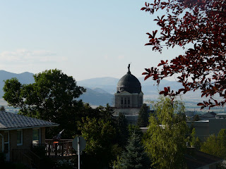
The public buildings include two standouts. The Greek Renaissance-style State Capitol, surmounted by a copper dome (left unpolished and, as a result, richly patinated thanks to oxidation) was, according to Liz, upon its completion in 1902 the first state capitol in the U.S. to have electric lights. Helena also boasts, really rather randomly, the St. Helena Cathedral, which was modeled after the famous cathedral in Cologne, Germany, and the Votive Church of Vienna. The first funeral to be held in the Cathedral, not too long after its completion, was that of the man who commissioned and paid for it, a heartbroken long-time widower who raised a daughter on his own only to see her "make some bad choices" and die of pneumonia (in the G-rated version anyway) at 19. Both the Capitol dome and the 230-foot spires of the Cathedral pop into your line of sight from all sorts of vantage points throughout Helena's hilly, easy-to-get-around 14 square miles, and they are as picturesque as they are unexpected.Among the mansions gold built are the original Governor's Mansion, a lovely Queen Anne on a beautiful lot. It housed 10 Montana governors until the new residence (quite hideous by comparison) was built in the 1950s. Oddly enough, neither the original nor the current Governor's Mansion is in the Mansion District, but that District is nevertheless rife with a large variety of other architecturally swanky homes, many featuring turrets, portes-cochères, wraparound porches, carriage houses, children's playhouses, lead-lined bathrooms, and other manifestations of the whims of their well-heeled owners.
During our two weeks in Helena, we lived in a "little mansion" complete with gorgeous woodwork, stained glass windows, fireplaces we never got to use, internet access, modern kitchen and bathrooms (thankfully), and a bewildering multiplicity of irons and cordless telephones. We discovered extraordinarily fresh vegetables, one first-rate and two very good restaurants, superb Gorgonzola salad dressing, and the best donuts we have had since we were children. Our days were punctuated by trips to the Y to swim (me), to Mt. Helena to hike (not me), and to all sorts of locations to eat and explore. The temperatures were warmer than we'd hoped, but we did get to see one humdinger of a thunderstorm and the sun shone until nearly 10 pm every evening.
The Capitol and the Cathedral:




 The original Governor's Mansion and a selection of homes in the Mansion District, all photographed too late in the afternoon on an extremely sunny day (sorry):


 Sprinkled around the Mansion District are ornate hitching posts, which serve as further reminders of both the area's Old West origins and the crazy things on which people will spend money. Click on the picture below to see the full magnitude of one resplendent hitching post as well as the original late 19th century brick sidewalk behind it.
 The "Guardian of the Gulch," another Helena icon, is a fire watch tower built in 1886. It's the most recent of a series of observation buildings and lookout stands to have stood on Tower Hill overlooking the Downtown District. For some inscrutable reason, it was made of wood even though all of its predecessors...you guessed it...burned down.
 Wildlife is everywhere in Montana, including in Helena. We encountered these deer nibbling on lawn foliage a few blocks from the original Governor's Mansion.


 Before the formation of the Rocky Mountains, the area that is now Montana was a gigantic inland sea, its bedrock at least 2.5 billion years old and its seabed thickly blanketed by seashells (a.k.a. the calcium carbonate that hardens into limestone). Three hundred million years ago, the Precambrian rocks of the Ancestral Rockies pushed their way up through that seabed. For the next hundred million years or so, these Ancestral Rockies eroded; the debris resulting from their erosion eventually solidified into new layers of sedimentary rock.
Fifty to 70 million years ago, the current Rockies began their rise, thanks to a colossal collision. When the Canadian Shield and Pacific tectonic plates smacked into each other, the lithosphere buckled and crunched, and molten rock from the mantle underneath pushed upward through the layers of sedimentary rock left behind by the Ancestral Rockies. (Click here if you missed Post 5 and would like definitions of these terms.)
The dinosaurs then wandering about would have felt all this buckling and pushing as earthquakes. Maybe it's a coincidence, maybe it's not, but the dinosaurs became extinct just as the granite from the mantle finally burst through the overlaying sandstone about 55-60 million years ago.
The evidence of this geology is everywhere in modern Montana, by area the fourth largest of the United States, by population the fourth smallest. Fewer than a million people live in this whole enormous state, so there's plenty of undisturbed room to take in both the spectacular vistas and the extraordinary sky. (I've written about the Montana sky before; "Big Sky Country" is a richly deserved nickname.)
On July 19, 1805, the Lewis and Clark expedition found itself on a remarkable stretch of the Missouri River about 20 miles north of what is now the city of Helena. Limestone cliffs (which Meriwether Lewis incorrectly thought were granite because it was raining and the wet stone looked black) rose up 1200 feet on both sides of the river. At each bend in the waterway, the looming stone walls looked as if they would block passage altogether, but then the river would curve and each time the walls opened like gates. Observing this, Lewis wrote in his journal, "I shall call this place Gates of the Mountains."
Lewis also wrote, "The river appears to have forced its way through this immense body of solid rock." This imagery, while apt, was again based on a mistake. (Lewis was no geologist.) In fact, the river predates the uplift of the cliffs around it. The Hilger Fault has been raising the northern end of the Big Belt Mountains and lowering the Helena valley for million of years. This forced (and continues to force) the Missouri to erode downward into the hard rock and carve the canyon that cuts across the mountains.
In the 204 years and 10 days since Lewis and Clark originally beheld it, the view has remained essentially unchanged. Limestone cliffs 1200 feet tall still manifest the extraordinary pressures of their formation in sensuous twists and curves and the effects of weathering in jutting ridges, domes and outcroppings. Areas of ancient Precambrian rock still alternate with the limestone. Cave openings abound. Ospreys, eagles, and falcons dot the sky. Bighorn sheep, mountain goats, otters, deer, squirrels and all manner of other wild animals roam the cliffs and flats. Pines grow thickly and reach for the sun.
And the silty waters of the Missouri continue to flow, powerfully placid.


 The pictographs in the cave pictured below were painted by Native Americans long before Lewis and Clark showed up here in 1805. The youngest of the pictographs dates to 400 years ago, the oldest to 1400 years ago.
 Among the fascinating rock formations in this Missouri River passage are three famous "faces." Can you find the Canyon Monster in the first photo below, the Stony Elephant (eyes and trunk) in the second, and the Eye of the Rhino (profile) in the third? (Click on the pictures if you want to make them larger.)

 Cave openings and a bald eagle in flight.


 The settlement of Southwest Montana is a story of mining - the excitement, the rush, the plundering, and the decline of chasing after gold and copper.
The first official U.S. visit to the territory was Lewis and Clark's 1805 expedition. In 1806, John Colter, a member of the expedition, struck out on his own, determined to make a fortune as a trapper and trader. When he returned to St. Louis four years later, he was a very rich man. Having likely been the first non-Native American to see what is now Yellowstone Park, he was also raving about boiling springs and smoke billowing from the ground. The people in St. Louis thought he was insane, but they were evidently willing to overlook insanity in the face of wealth. Companies (including John Jacob Astor's) and hundreds of freelancers lit out for the wilderness. These trappers brought back more than half a million beaver pelts annually for 30 years. By the 1840s, beavers were all but extinct in the Rockies and the Montana Territory was reliably to be found on the white man's maps.
For the next 20 years or so, people pretty much went through Montana on their way further west. But everything changed when prospectors struck gold in 1862, 1863 and 1864.
 The last strike was at Last Chance Gulch in what is now Helena. This was a rich strike: in today's dollars, $3.6 billion in gold was mined from 1864-1884. To this day, the main drag of Helena's cute downtown is called Last Chance Gulch. (How great an address is 1200 Last Chance Gulch? North of downtown, it's the YMCA where I go to swim while we're here.)
Mines, railroads, ranches and lawlessness flourished in the Montana Territory from 1862 until nearly the turn of the century. But a brutal winter in 1887 dealt a harsh blow to ranchers and began the decline of the Old West. The U.S. Congress ended silver subsidies in 1893, which ruined the market and caused the collapse of silver mines throughout the Rockies. The same thing happened to the gold market in 1933.
The story of copper mining continued into the 1970s, but it, too, ends badly - a rise and fall nowhere better illustrated than in Anaconda.
We visited Anaconda, a city of 10,000 people about 50 miles northwest of Butte, on one of our side trips from Helena. In the 1880s, the Butte area became the world's largest copper producer. Over 19 billion pounds of ore were unearthed by hard-rock miners over the following decades; the copper was then extracted by smelters and shipped all over the world.
Anaconda was founded in 1883 when legendary "copper king" Marcus Daly built a copper smelter and reduction works there as part of his ongoing battle for domination of the Butte-area copper industry. From 1892-1903, the Anaconda Copper Company was the largest copper mine in the world; over its lifetime, it produced $300 billion worth of the metal. In 1899, the company was merged into Rockefeller's Standard Oil Company, in a brazen sleight-of-financial-hand deal that made a few people exceedingly rich and led, among other things, to the eventual enactment of U.S. antitrust laws.
Anaconda Copper was shut down in 1980, a casualty of the decrease in worldwide demand for copper, decline in ore grades, and rising mining costs. (The takeover in 1971 by Socialist President Allende of Anaconda's huge Chuquicamata mine in Chile didn't help much either.)
All that remains of the operation now is the Anaconda Smelter Stack, one of the tallest freestanding brick structures in the world. At 585 feet, the stack is taller than the Washington Monument; it now looms sadly over the landscape from its position atop a hill next to what appears to be a slag heap. I'm not sure exactly what to make of the fact that this giant phallic symbol is the sole remnant of years of fabulous wealth, back-breaking work, financial chicanery, environmental devastation, and worldwide domination.
 Befitting its wealth and status, Anaconda was once an opulent city. By 1898, it boasted mansions (small by East Coast and Midwestern standards, but grand indeed in the Old West), fancy churches, and other grandiose buildings, including the Hearst Free Library (George Hearst, William Randolph's father, was one of Daly's investors) and the Washoe Theater (978 seats, Art Deco, and rated by the Smithsonian as one of the most beautiful interiors in the United States). Like the Anaconda Smelter Stack, this all looks sad today, run-down and/or abandoned as it is.
On Highway 1, the road to and from Anaconda, you pass the towns of Wisdom and Opportunity. I wonder if the same person named both and, if so, whether he meant the two names to be taken optimistically (the southbound Wisdom, then Opportunity) or pessimistically (the northbound Wisdom after Opportunity).


 Today was a leisurely driving day. It turns out that the only sensible way to get from Grand Teton National Park to Helena, MT (our home away from home for the next little while) is to go through Yellowstone. Perhaps not the best plan for a Saturday, we thought as we approached the Park's South Entrance. Definitely not the best plan, we worried, when the ranger at the gate declined our National Park Pass, telling us in that wholesome, cheery, enthusiastic ranger way that it was a "free weekend."
But our worries were unfounded. We've been to Yellowstone before (and didn't love it), so this time we elected to forgo the usual sights in favor of staying on US 89 and getting through the Park as quickly as possible. Probably because it bypasses the most popular tourist spots, this generally northwesterly route was uncongested even on a free weekend. It twists and turns, mostly at a nice 45mph clip, past some magnificent scenery and wildlife, including the preternaturally serene buffalo in the picture above. (Among the things that did not appear to be troubling this "so ugly he's actually sort of beautiful" creature was his extreme need for lotion and hair conditioner.)
Don't miss the fumaroles in the picture just below. (Click on the picture to see a larger version.) These steam spouts billow out of the ground more or less constantly all over Yellowstone. Like their flashier cousins the geysers, fumaroles are an unexpected and bewitching thrill to the eye; to the mind, they somewhat sinisterly confirm that boiling away not very far underground is the same magmatic heat that powered the violent volcanic eruptions that created, shaped and reshaped Yellowstone's topography.


 Most of Yellowstone is a high volcanic plateau. But the northern portion of the Park and the chunk of south-central Montana you find yourself in immediately after you leave the Park through the North Entrance are more geologically complex.
Landslides, more erodible shales and sandstones, and glacial till deposits of a whole host of rock types make for a very different landscape in this area of the northern range. The soils here have a high clay content. Water binds tightly to clay, which results in very little water being available to sustain plants. In case that alone wasn't enough to discourage plant growth, these soils are also poorly aerated, they resist root growth, and they have high levels of sodium and salts. For all these reasons, the landscape stops looking lushly green and looks instead like this: Sparkling streams, creeks and the impressive Yellowstone River, complete with rafters, kayakers, waders and swimmers, contrast implausibly but gorgeously with this rugged landscape.
We stop for gas in tiny Gardiner, MT, and enjoy both the cowboy boots on the residents, male and female, and the wonderfully named Hellroaring Street we pass on the way out of town. By the time we get to Livingston, it's midafternoon and we're hungry. Relying once again on Jane and Michael Stern's Roadfood book, we head for the Sport Restaurant on Main Street. But for all the trucks and SUVs, the street looks to be straight out of a Western.
After hamburgers topped with a veritable salad of incredibly fresh and delicious lettuce, tomatoes and mushrooms (where on earth could they be from, we wonder), a pile of crisp garlicky fries, and an enjoyable chat with our waiter (David, originally from St. Louis), we hop back in the car, realize that it would really be far more appropriate to unhitch horses and hop on them instead, and head for Helena.
 I'm not really a fan of those historical tours you can take in almost every city and town. For one thing, they're typically conducted in modes of transportation either so cute it makes your teeth ache (e.g., locomotives like the kiddie trains at amusement parks, double-decker buses, trolley cars, and so forth, all of them inevitably red) or so uncomfortable you soon believe it would be altogether better simply to throw yourself through the window (e.g., noisy diesel buses with cramped, high-backed seats molded to allow only one totally disagreeable sitting position).
 The town site of Helena was first surveyed in 1865, but most of the streets - then and now - meandered as had the miners, following the curves of Last Chance Creek and circumventing miners' claims. Even then, naming things Last Chance one thing or another must have been irresistible. It certainly is today. My favorite was the (I suspect inadvertently) sinister Last Chance Splash Swimming Pool & Water Park.


