 Borders, like time, have always seemed a little silly to me. They're merely constructs, real only because we agree to consider them so. At the Waterton-Glacier International Peace Park, established in 1932, Canada and the United States decided to agree otherwise for one segment of the line on the map dividing them. Marked only by a couple of white markers, one on the ground, one high atop a ridge, and a swath cut in the forest at the 49th Parallel, that segment is the longest undefended border in the world.
The peace and trust signified by the decision to ignore the border seem utterly at home in serene Upper Waterton Lake (pictured above) and the rest of this magnificent park. There's a super-abundance of beauty here: craggy peaks; gentle slopes; sheer drops; deep chasms carpeted in green and taupe; thick forests; glittering waterfalls; vast pristine lakes hundreds of feet deep, most of them astonishingly clear, others tinted turquoise by suspended glacial silt; even the engineering marvel that is the Going-to-the-Sun Road.
I've written about these beauties before and barely scratched the surface. It's tempting to go over that territory again or to mention cool facts I left out the first time, such as Triple Divide Peak. The Continental Divide winds its way through the Northern Rockies; at Triple Divide Peak, not two, but three watersheds intersect. Depending on exactly where it falls on the Peak, a raindrop will ultimately end up in the Hudson Bay, the Pacific Ocean or the Gulf of Mexico. An area only as big as the span of a hand determines which direction the drop will travel.
Instead, though, I'm going to write about glaciers, my absolute favorite geological phenomenon and the reason Waterton-Glacier looks the way it does. Its topography is a textbook illustration of the effects of glaciation - if the textbook were the educational equivalent of an illuminated manuscript.
Glaciers cover about five million square miles of Earth's surface, four million over Antarctica, 750,000 over Greenland and the other quarter-million scattered around the rest of the world. Glacial ice is the largest reservoir of fresh water on the planet, and is second only to the oceans as the largest reservoir of total water. As such, glaciers are crucial to both world water resources and variations in sea level.
And they are fast disappearing. In Glacier NP, for example, there were 150 at the end of the cooling trend known as the Little Ice Age (1550-1850). By the middle of the 20th century, there were 50; in 2005, there were 27. If global warming continues at current levels, all the glaciers in the park will be gone by 2030.
That will be very sad, not only for aesthetic, fresh water or sea level reasons, but also because glaciers are an extraordinary phenomenon and the sculptors of some of the most striking landscapes on Earth. Glacial ice comes in second to streams as an agent of erosion, but what a glorious second.
Glaciers are the beautiful ice-blue result of climates cold enough to permit snow and ice to survive year-round. When over time the amount of snow that falls is greater than the amount that melts, a remarkable transformation takes place. Delicate snowflakes are converted by a process called sublimation into vapor that instantly recrystallizes into a granular ice called firn or névé. The sand-sized crystals then bump into each other and melt at their points of contact. The resulting water flows into the spaces between the grains and instantly refreezes, creating a mass of glacial ice.
Once the mass reaches a thickness of 150 feet, the weight of the top ice causes the bottom ice to become plastic and flow. Remember, in geology "plastic" means neither a liquid nor a solid. The rocks in the asthenosphere portion of the mantle are likewise plastic and for the same reason: the weight of the overlying rocks in the lithosphere. Plastic flow occurs because the ice (or, in the case of the asthenosphere, the rock) is composed of layers of molecules stacked on top of one another with relatively weak bonds between the layers. When the stress caused by the weight of a higher layer exceeds the strength of the bonds between the layers, the top layer moves faster than the layer below. Voilà! Plasticity.
I understand plastic flow and I can explain it, but it seems magical to me anyway and it's one of the big reasons I love glaciers. Another is the way they operate. As glaciers advance (which means grow in size), they erode the rock under them spectacularly. They're very workmanlike about this, despite the dramatic results. Glaciers physically remove chunks from the underlying bedrock and pull them up into the ice. (This process, called quarrying or plucking, is accomplished by the very same eons-long freeze-thaw process that carved Bryce Canyon's eye-popping rock formations.) The rocks so taken up in the ice abrade the bedrock over which the glacier moves, effectively turning the flowing ice into a colossal piece of sandpaper that scours, polishes and stripes the surface below.
Glaciers come in two varieties: the stodgy-seeming continental (like Antarctica and Greenland) and the flamboyant alpine (like the rest). What they do is identical: form, advance, retreat, and erode the landscape. How they do it and what it looks like when they're done are very different.
Continental glaciers form only in polar regions and they sit on huge horizontal surfaces. Constantly falling snow causes the ice to collapse under its own weight, which moves the whole mass. The movement is very slow, only 15 feet or so per year. When they eventually retreat, continental glaciers leave landscapes that look like Canada east of the Rockies or the Finger Lakes region of upstate New York. This topography may seem boring, but it is, in fact, the result of ultra-dramatic glacial activity. Advancing continental glaciers actually increase the relief of the bedrock over which they move. But when they retreat (think "melt"), they deposit gigantic loads of glacial till (the stuff they've quarried along the way over eons). The till piles up and piles up, and eventually it reaches and buries the high-relief peaks, turning the landscape into flat or very gently rolling plains dotted with depressions where water collects into lakes.
Alpine glaciers are the showboats, much flashier in terms of how they move and the landscape they leave behind. They form in the headwaters of V-shaped mountain stream valleys. First, the growing mass of ice digs a bowl into the mountainside called a cirque. Eventually, the ice overflows its cirque and goes careening down the mountain (well, geologically speaking - the rate of movement is typically a foot or so a day). The glacier spills into the stream valley below and transforms the existing V-shape into the tranquil, soothing U-shape characteristic of glacially created valleys.

 Alpine glaciers indulge in a bunch of other acrobatics as well. They can form in adjacent valleys on two sides of a mountain and eventually sculpt knife-sharp ridges (aretes). They can tunnel through ridges and create high mountain passes (cols). They can get together and gang up on all sides of a mountain peak to create a horn (think of the Matterhorn or the Grand Tetons).


The forces of gravity that caused alpine glaciers to spill down mountainsides in the first place are still at work when these glaciers retreat. They deposit their quarried loads in moraines below and sometimes astride the cirques, filling up valleys (remember Jackson Hole?), but leaving the highest ground craggy, the cirque basins filled with glacier remnants or cold clearwater lakes (called tarns), and the slopes down which they flowed polished, striped and spectacular. The sculpting effected by alpine glaciers is superimposed on topography already carved by streams, and the combination is what we have to thank for scenery as incredible as the Northern Rockies and the Alps.
Although they, too, are in retreat, the Mendenhall Glacier in the Juneau icefield and especially the Hubbard Glacier in Alaska's Yakutat Bay retain miens of power. It is possible to look at them and see as well as comprehend the gargantuan work they've done and still do.
By contrast, the glaciers in Waterton-Glacier NP are small, outwardly inert, sad even. They seem to be clinging by their metaphorical fingernails to their cirque basins and mountainsides as if for dear life. If you know nothing about how glaciers work, you might find them pathetic. Armed with knowledge, however, you have to be impressed. With their dazzling handiwork spread out around and below them, Glacier's glaciers are like proud great-grandparents at the head of the table - aware that their work is done and content in the realization that they did a superlative job.


 We saw a veritable wildlife jamboree on this visit: a black bear; a perfectly posed ring of bighorn sheep; a more independent, but equally picturesque, lone bighorn; a deer wandering through the Logan Pass parking lot looking for all the world like a prospective car buyer checking out the inventory; three mountain goats, including the baby pictured below; a stag that sauntered up to a hedge, sat, stretched his elegant neck, posed thusly for 15 minutes, then rose and sauntered off, his shift apparently over; and another black bear.


 I'm not really a fan of those historical tours you can take in almost every city and town. For one thing, they're typically conducted in modes of transportation either so cute it makes your teeth ache (e.g., locomotives like the kiddie trains at amusement parks, double-decker buses, trolley cars, and so forth, all of them inevitably red) or so uncomfortable you soon believe it would be altogether better simply to throw yourself through the window (e.g., noisy diesel buses with cramped, high-backed seats molded to allow only one totally disagreeable sitting position).
For another thing, these tours are always conducted/driven by an enthusiastic, big-personality jokester, the kind of person who asks where everyone is from and instructs the crowd to give Bill the ticket guy a round of applause because he's the one who washed the windows so everyone would have a nice clear view - this on an open-air vehicle that has no windows. Ha-ha. Being an extrovert and a public speaker myself, I feel bad if I leave these people hanging, so I end up playing along and feeling instead both imposed upon and like a chump. It's exhausting, really.
But my husband loves the tours and, with rare exceptions, he's been right about their value, despite the drawbacks. They're a great way to get the lay of the land and a sense of the local scenery and history. The tour in Helena, MT, was not an exception. It took place in a tricked-out locomotive that pulled three open-air cars (the whole thing cherry-red, of course), and it was conducted by an exceptionally chipper woman named Liz who looked about 25, but told us she was the mother of three daughters, two of them teenagers, and the wife of a man who often "feels he's swimming in an estrogen ocean." She also mentioned her father, her brothers and that she's planning a run next year for the Montana state senate.
Liz managed to tell us a great deal about Helena, too, as she trundled her super-cute tour vehicle around town. I owe her - and the Helena Chamber of Commerce website, which disagrees with her on a few matters - a debt of gratitude for the tidbits I've woven into the tale below.
The last of the three huge gold strikes in Montana's history was discovered by four prospectors known for unclear reasons as the Four Georgians. Apparently, only one of them was from Georgia, but all of them had decided to go home empty-handed if they didn't strike gold in the gulch along the Last Chance Creek. The gold they found there in 1864 began one of the largest gold rushes in the West.
 The town site of Helena was first surveyed in 1865, but most of the streets - then and now - meandered as had the miners, following the curves of Last Chance Creek and circumventing miners' claims. Even then, naming things Last Chance one thing or another must have been irresistible. It certainly is today. My favorite was the (I suspect inadvertently) sinister Last Chance Splash Swimming Pool & Water Park.
By 1888, fifty millionaires lived in Helena, more per capita than in any other city on earth. As millionaires are wont to do, these flush late 19th century versions built grand mansions, cathedrals and public buildings, and stooped as low as necessary to make sure that their Helena, which had become the capital of the Montana Territory in 1875, was also designated the state capital when Montana joined the Union in 1889. Arms were twisted, votes were purchased, and it's said that more votes were cast for Helena as the new state's capital than there were residents in the Territory.
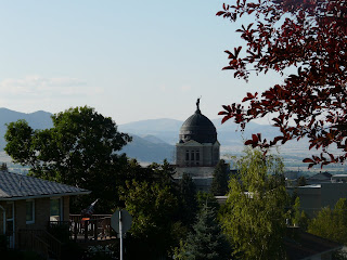
The public buildings include two standouts. The Greek Renaissance-style State Capitol, surmounted by a copper dome (left unpolished and, as a result, richly patinated thanks to oxidation) was, according to Liz, upon its completion in 1902 the first state capitol in the U.S. to have electric lights. Helena also boasts, really rather randomly, the St. Helena Cathedral, which was modeled after the famous cathedral in Cologne, Germany, and the Votive Church of Vienna. The first funeral to be held in the Cathedral, not too long after its completion, was that of the man who commissioned and paid for it, a heartbroken long-time widower who raised a daughter on his own only to see her "make some bad choices" and die of pneumonia (in the G-rated version anyway) at 19. Both the Capitol dome and the 230-foot spires of the Cathedral pop into your line of sight from all sorts of vantage points throughout Helena's hilly, easy-to-get-around 14 square miles, and they are as picturesque as they are unexpected.Among the mansions gold built are the original Governor's Mansion, a lovely Queen Anne on a beautiful lot. It housed 10 Montana governors until the new residence (quite hideous by comparison) was built in the 1950s. Oddly enough, neither the original nor the current Governor's Mansion is in the Mansion District, but that District is nevertheless rife with a large variety of other architecturally swanky homes, many featuring turrets, portes-cochères, wraparound porches, carriage houses, children's playhouses, lead-lined bathrooms, and other manifestations of the whims of their well-heeled owners.
During our two weeks in Helena, we lived in a "little mansion" complete with gorgeous woodwork, stained glass windows, fireplaces we never got to use, internet access, modern kitchen and bathrooms (thankfully), and a bewildering multiplicity of irons and cordless telephones. We discovered extraordinarily fresh vegetables, one first-rate and two very good restaurants, superb Gorgonzola salad dressing, and the best donuts we have had since we were children. Our days were punctuated by trips to the Y to swim (me), to Mt. Helena to hike (not me), and to all sorts of locations to eat and explore. The temperatures were warmer than we'd hoped, but we did get to see one humdinger of a thunderstorm and the sun shone until nearly 10 pm every evening.
The Capitol and the Cathedral:




 The original Governor's Mansion and a selection of homes in the Mansion District, all photographed too late in the afternoon on an extremely sunny day (sorry):


 Sprinkled around the Mansion District are ornate hitching posts, which serve as further reminders of both the area's Old West origins and the crazy things on which people will spend money. Click on the picture below to see the full magnitude of one resplendent hitching post as well as the original late 19th century brick sidewalk behind it.
 The "Guardian of the Gulch," another Helena icon, is a fire watch tower built in 1886. It's the most recent of a series of observation buildings and lookout stands to have stood on Tower Hill overlooking the Downtown District. For some inscrutable reason, it was made of wood even though all of its predecessors...you guessed it...burned down.
 Wildlife is everywhere in Montana, including in Helena. We encountered these deer nibbling on lawn foliage a few blocks from the original Governor's Mansion.


 Before the formation of the Rocky Mountains, the area that is now Montana was a gigantic inland sea, its bedrock at least 2.5 billion years old and its seabed thickly blanketed by seashells (a.k.a. the calcium carbonate that hardens into limestone). Three hundred million years ago, the Precambrian rocks of the Ancestral Rockies pushed their way up through that seabed. For the next hundred million years or so, these Ancestral Rockies eroded; the debris resulting from their erosion eventually solidified into new layers of sedimentary rock.
Fifty to 70 million years ago, the current Rockies began their rise, thanks to a colossal collision. When the Canadian Shield and Pacific tectonic plates smacked into each other, the lithosphere buckled and crunched, and molten rock from the mantle underneath pushed upward through the layers of sedimentary rock left behind by the Ancestral Rockies. (Click here if you missed Post 5 and would like definitions of these terms.)
The dinosaurs then wandering about would have felt all this buckling and pushing as earthquakes. Maybe it's a coincidence, maybe it's not, but the dinosaurs became extinct just as the granite from the mantle finally burst through the overlaying sandstone about 55-60 million years ago.
The evidence of this geology is everywhere in modern Montana, by area the fourth largest of the United States, by population the fourth smallest. Fewer than a million people live in this whole enormous state, so there's plenty of undisturbed room to take in both the spectacular vistas and the extraordinary sky. (I've written about the Montana sky before; "Big Sky Country" is a richly deserved nickname.)
On July 19, 1805, the Lewis and Clark expedition found itself on a remarkable stretch of the Missouri River about 20 miles north of what is now the city of Helena. Limestone cliffs (which Meriwether Lewis incorrectly thought were granite because it was raining and the wet stone looked black) rose up 1200 feet on both sides of the river. At each bend in the waterway, the looming stone walls looked as if they would block passage altogether, but then the river would curve and each time the walls opened like gates. Observing this, Lewis wrote in his journal, "I shall call this place Gates of the Mountains."
Lewis also wrote, "The river appears to have forced its way through this immense body of solid rock." This imagery, while apt, was again based on a mistake. (Lewis was no geologist.) In fact, the river predates the uplift of the cliffs around it. The Hilger Fault has been raising the northern end of the Big Belt Mountains and lowering the Helena valley for million of years. This forced (and continues to force) the Missouri to erode downward into the hard rock and carve the canyon that cuts across the mountains.
In the 204 years and 10 days since Lewis and Clark originally beheld it, the view has remained essentially unchanged. Limestone cliffs 1200 feet tall still manifest the extraordinary pressures of their formation in sensuous twists and curves and the effects of weathering in jutting ridges, domes and outcroppings. Areas of ancient Precambrian rock still alternate with the limestone. Cave openings abound. Ospreys, eagles, and falcons dot the sky. Bighorn sheep, mountain goats, otters, deer, squirrels and all manner of other wild animals roam the cliffs and flats. Pines grow thickly and reach for the sun.
And the silty waters of the Missouri continue to flow, powerfully placid.


 The pictographs in the cave pictured below were painted by Native Americans long before Lewis and Clark showed up here in 1805. The youngest of the pictographs dates to 400 years ago, the oldest to 1400 years ago.
 Among the fascinating rock formations in this Missouri River passage are three famous "faces." Can you find the Canyon Monster in the first photo below, the Stony Elephant (eyes and trunk) in the second, and the Eye of the Rhino (profile) in the third? (Click on the pictures if you want to make them larger.)

 Cave openings and a bald eagle in flight.


 Borders, like time, have always seemed a little silly to me. They're merely constructs, real only because we agree to consider them so. At the Waterton-Glacier International Peace Park, established in 1932, Canada and the United States decided to agree otherwise for one segment of the line on the map dividing them. Marked only by a couple of white markers, one on the ground, one high atop a ridge, and a swath cut in the forest at the 49th Parallel, that segment is the longest undefended border in the world.


